Skip to content
ProjectsResearch

Glacial Lake Outburst Flood (GLOF)

Our objective is to establish a national-scale, technology-enabled GLOF risk monitoring and mitigation platform, beginning with high-risk catchments such as the Punatsangchhu basin.

Research team
Research team

Project description

The GLOF Initiative is being developed as a national IoT-enabled climate resilience infrastructure platform, integrating high-altitude sensor networks, real-time telemetry, satellite feeds, and AI/ML-driven analytics to continuously monitor glacial lakes, moraine stability, hydrological fluctuations, and downstream exposure. As glacier retreat accelerates, predictive modeling and machine-learning–based anomaly detection allow early risk identification, automated alert generation, and scenario-based flood simulation—making proactive intervention far more cost-effective than post-disaster reconstruction. InnoTech’s ongoing work in advanced sensor deployment and basin-scale data integration provides the technical backbone to scale this into a fully integrated, data-driven GLOF risk intelligence system, positioning Bhutan as a global benchmark for smart, technology-enabled mountain climate adaptation.


Why this Matters Now

<span style="background-color: transparent;"><span style="color: rgb(102, 102, 102);"><span style="font-family: Avenir, sans-serif;"><span style="font-size: 11pt;">Bhutan is one of the most climate-vulnerable mountainous countries in the world. Rising temperatures are accelerating glacier melt, increasing the formation and expansion of glacial lakes, many of which are potentially unstable.</span></span></span></span>

<span style="background-color: transparent;"><span style="color: rgb(102, 102, 102);"><span style="font-family: Avenir, sans-serif;"><span style="font-size: 13pt;">The Initiative Includes:</span></span></span></span>

<span style="background-color: transparent;"><span style="color: rgb(102, 102, 102);"><span style="font-family: Avenir, sans-serif;"><span style="font-size: 13pt;">A. Advanced Monitoring & Sensor Deployment</span></span></span></span>
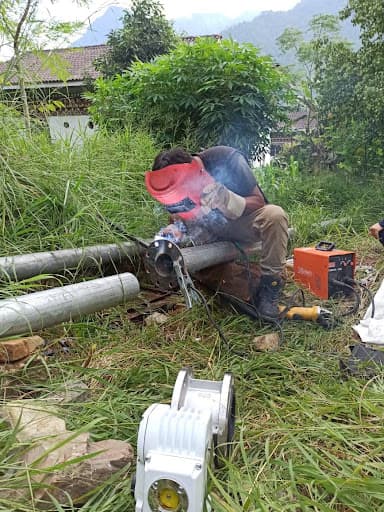
<span style="background-color: transparent;"><span style="color: rgb(102, 102, 102);"><span style="font-family: Avenir, sans-serif;"><span style="font-size: 11pt;">Installation of real-time hydrological and geotechnical sensors</span></span></span></span>
<span style="background-color: transparent;"><span style="color: rgb(102, 102, 102);"><span style="font-family: Avenir, sans-serif;"><span style="font-size: 11pt;">Water level monitoring systems</span></span></span></span>
<span style="background-color: transparent;"><span style="color: rgb(102, 102, 102);"><span style="font-family: Avenir, sans-serif;"><span style="font-size: 11pt;">Seismic and pressure sensors for moraine stability</span></span></span></span>
<span style="background-color: transparent;"><span style="color: rgb(102, 102, 102);"><span style="font-family: Avenir, sans-serif;"><span style="font-size: 11pt;">Satellite-linked telemetry systems</span></span></span></span>
<span style="background-color: transparent;"><span style="color: rgb(102, 102, 102);"><span style="font-family: Avenir, sans-serif;"><span style="font-size: 11pt;">AI-driven data integration platform</span></span></span></span>
<span style="background-color: transparent;"><span style="color: rgb(102, 102, 102);"><span style="font-family: Avenir, sans-serif;"><span style="font-size: 13pt;">B. Early Warning Systems (EWS)</span></span></span></span>
<span style="background-color: transparent;"><span style="color: rgb(102, 102, 102);"><span style="font-family: Avenir, sans-serif;"><span style="font-size: 11pt;">Automated alert systems downstream</span></span></span></span>
<span style="background-color: transparent;"><span style="color: rgb(102, 102, 102);"><span style="font-family: Avenir, sans-serif;"><span style="font-size: 11pt;">SMS-based community notification systems</span></span></span></span>
<span style="background-color: transparent;"><span style="color: rgb(102, 102, 102);"><span style="font-family: Avenir, sans-serif;"><span style="font-size: 11pt;">Integration with national disaster management systems</span></span></span></span>
<span style="background-color: transparent;"><span style="color: rgb(102, 102, 102);"><span style="font-family: Avenir, sans-serif;"><span style="font-size: 11pt;">Siren towers and rapid response mechanisms </span></span></span></span>
<span style="background-color: transparent;"><span style="color: rgb(102, 102, 102);"><span style="font-family: Avenir, sans-serif;"><span style="font-size: 13pt;">C. Risk Modeling & Basin Simulation</span></span></span></span>
<span style="background-color: transparent;"><span style="color: rgb(102, 102, 102);"><span style="font-family: Avenir, sans-serif;"><span style="font-size: 11pt;">Hydrodynamic flood modeling</span></span></span></span>
<span style="background-color: transparent;"><span style="color: rgb(102, 102, 102);"><span style="font-family: Avenir, sans-serif;"><span style="font-size: 11pt;">Catchment-wide risk mapping</span></span></span></span>
<span style="background-color: transparent;"><span style="color: rgb(102, 102, 102);"><span style="font-family: Avenir, sans-serif;"><span style="font-size: 11pt;">Infrastructure exposure analysis (hydropower plants, bridges, communities)</span></span></span></span>
<span style="background-color: transparent;"><span style="color: rgb(102, 102, 102);"><span style="font-family: Avenir, sans-serif;"><span style="font-size: 13pt;"></span></span></span></span>
<span style="background-color: transparent;"><span style="color: rgb(102, 102, 102);"><span style="font-family: Avenir, sans-serif;"><span style="font-size: 13pt;">Climate Acceleration</span></span></span></span>

<span style="background-color: transparent;"><span style="color: rgb(102, 102, 102);"><span style="font-family: Avenir, sans-serif;"><span style="font-size: 11pt;">The Eastern Himalayas are warming faster than the global average. Several glacial lakes in Bhutan have expanded significantly over the past decades.</span></span></span></span>

<span style="background-color: transparent;"><span style="color: rgb(102, 102, 102);"><span style="font-family: Avenir, sans-serif;"><span style="font-size: 13pt;">Strategic Infrastructure Exposure</span></span></span></span>

<span style="background-color: transparent;"><span style="color: rgb(102, 102, 102);"><span style="font-family: Avenir, sans-serif;"><span style="font-size: 11pt;">Bhutan’s hydropower assets—including major projects in the Punatsangchhu basin—are exposed to upstream GLOF risks. A single catastrophic event could:</span></span></span></span>

<span style="background-color: transparent;"><span style="color: rgb(102, 102, 102);"><span style="font-family: Avenir, sans-serif;"><span style="font-size: 11pt;">Disrupt gigawatt-scale power generation</span></span></span></span>
<span style="background-color: transparent;"><span style="color: rgb(102, 102, 102);"><span style="font-family: Avenir, sans-serif;"><span style="font-size: 11pt;">Damage export revenue streams</span></span></span></span>
<span style="background-color: transparent;"><span style="color: rgb(102, 102, 102);"><span style="font-family: Avenir, sans-serif;"><span style="font-size: 11pt;">Impact national GDP stability</span></span></span></span>
<span style="background-color: transparent;"><span style="color: rgb(102, 102, 102);"><span style="font-family: Avenir, sans-serif;"><span style="font-size: 13pt;">Economic & Human Risk</span></span></span></span>

<span style="background-color: transparent;"><span style="color: rgb(102, 102, 102);"><span style="font-family: Avenir, sans-serif;"><span style="font-size: 11pt;">Downstream communities, agricultural land, bridges, and highways remain vulnerable.</span></span></span></span>

<span style="background-color: transparent;"><span style="color: rgb(102, 102, 102);"><span style="font-family: Avenir, sans-serif;"><span style="font-size: 13pt;"></span></span></span></span>
<span style="background-color: transparent;"><span style="color: rgb(102, 102, 102);"><span style="font-family: Avenir, sans-serif;"><span style="font-size: 13pt;">Global Climate Finance Momentum</span></span></span></span>

<span style="background-color: transparent;"><span style="color: rgb(102, 102, 102);"><span style="font-family: Avenir, sans-serif;"><span style="font-size: 11pt;">Adaptation finance is now a global priority under COP frameworks, making this the right moment to mobilize:</span></span></span></span>

<span style="background-color: transparent;"><span style="color: rgb(102, 102, 102);"><span style="font-family: Avenir, sans-serif;"><span style="font-size: 11pt;">Green Climate Fund</span></span></span></span>
<span style="background-color: transparent;"><span style="color: rgb(102, 102, 102);"><span style="font-family: Avenir, sans-serif;"><span style="font-size: 11pt;">Loss & Damage mechanisms</span></span></span></span>
<span style="background-color: transparent;"><span style="color: rgb(102, 102, 102);"><span style="font-family: Avenir, sans-serif;"><span style="font-size: 11pt;">Climate resilience bonds</span></span></span></span>
<span style="background-color: transparent;"><span style="color: rgb(102, 102, 102);"><span style="font-family: Avenir, sans-serif;"><span style="font-size: 11pt;">Multilateral development financing</span></span></span></span>

Why Bhutan and Why InnoTech


Over 600 glacial lakes, with several identified as potentially dangerous
Heavy reliance on hydropower (economic backbone)
Strong national commitment to climate leadership
Carbon-negative country with global environmental credibility
Compact geography suitable for integrated monitoring systems

Real-world impact.

Working in collaboration with Newcastle University on sensor deployment research
Engaged in basin-level hydrological and monitoring initiatives
Exploring integrated monitoring frameworks in Punatsangchhu and related catchments
Bridging academic research with applied infrastructure solutions

Investment Required/Project Cost:

Phase 1 – Detailed Risk Assessment & Monitoring Deployment
Sensor networks (remote, high-altitude capable)
Data platform & modeling software
Satellite integration Estimated: USD 5–15 million
Phase 2 – Early Warning System Scaling
Community siren systems
Downstream alert infrastructure
National disaster integration Estimated: USD 10–25 million
Phase 3 – Structural Mitigation (Site-Specific)
Controlled lake drainage
Spillway engineering
River training works Estimated: USD 20–80+ million per high-risk lake

Want to collaborate on this project? Write the lead directly, or pitch an adjacent idea through the open queue.

More projects

All projects →
Field Site Deployment
Deployed
IoTThimphu, Semjong, Gyalpozhing

Smart Water Management System

An IoT-enabled Smart Water Management System designed to improve water distribution, reduce wastage, and ensure reliable access to safe drinking water. The system integrates smart sensors for water quality, pressure, and flow monitoring, supported by remote monitoring and control to detect anomalies and optimize water supply from source to end users. Currently being piloted in Bhutan, the solution has potential for regional and international scale-up.

Read the case
Bhutan LLM
Research
AI / MLThimphu

Bhutan LLM : National LLM + Data Lake

The Bhutan Sovereign LLM Initiative, led by DHI InnoTech, aims to build a national AI layer for Bhutan, which is a secure, sovereign Large Language Model integrated with a structured National Data Lake. This platform will: Aggregate structured and unstructured national datasets. Serve as a sovereign knowledge engine trained on Bhutan-specific data. Power AI agents capable of policy analysis, institutional intelligence, and public-facing services. Act as a digital extension of Bhutan. It will be a responsible AI representation of the Kingdom for both domestic governance and international engagement. The initiative envisions Bhutan not merely as a consumer of global AI systems but as a creator of a nationally aligned intelligence layer, grounded in Bhutanese values, governance structures, and development priorities. The deployment architecture remains flexible: Phase 1 (Prototype): Agent-based architecture built on leading AI APIs. Phase 2 (Conditional on Funding): Migration to sovereign GPU infrastructure hosted within Bhutan. Alternative Path: Continued operation on secure global cloud infrastructure if capital expenditure is constrained. The system is being developed as modular, interoperable, and sovereign by design.

Read the case
RikhaNet
Deployed
JNWSFLNubi Gewog (Bhutan)

RiKhaNET: Realtime Integrated Knowledge on Habitat & Animals – Network

RiKhaNET addresses a core operational challenge in Bhutan’s tiger landscapes where field data and incident information are often fragmented across tools and stakeholders, limiting timely prevention. RiKhaNET consolidates these inputs into a single, governed platform by integrating Bhutan’s SMART (Spatial Monitoring and Reporting Tool) data with AI-driven analytics and real-time sensor inputs. Using machine-learning models, the system generates dynamic risk heatmaps, geofencing alerts, and automated notifications to help rangers and communities anticipate conflict hotspots before incidents occur, shifting response from reactive to proactive prevention. The Stakeholder meetings conducted emphasized that the pilot must be designed to strengthen trust and adoption, not only technology performance. Three design requirements were highlighted: Data governance and transparency: The current hosting arrangements raise concerns about filtering, access control, and sensitive wildlife-location data; governance must be explicit and communicated clearly. Community safety communication: The alert systems must be carefully designed so alerts support prevention and coordinated action rather than increasing fear; community focal persons can strengthen trusted communication. Operational realism for detection: It has been noted that tiger detections can be rare; deployments may run for months yet capture limited tiger events, so the pilot should prioritize focused hotspot monitoring with sufficient duration to produce meaningful training and pattern data.

Read the case